
NYC Winters: Precipitation Types & Changing Times
A few months back I decided to take a look at the number of days during which there is measurable rain vs measurable snow during climatological winter (December 1 to March 1) in the NYC area. This was partly inspired by the fact that many people seem to think it is "supposed to" snow during this time of year, and rainfall is something that only happens when the pattern has gone astray thus destroying a perfect winter of all snow, all the time.
Anyone who has lived in this part of the country knows that rain is very much a part of typical winters around NYC. Still, I was interested enough to try to quantify the extent to which we should expect rain vs. snow for the coldest months of the year.
The number of days with measurable precipitation (rain or frozen precipitation) and measurable snowfall are both readily available and easy to compile. Finding the number of days with measurable rainfall is not as straightforward. The method I used to determine the number of days with rainfall was simply by subtracting the number of days with measurable snow from the number of days with measurable precipitation. The drawback to using this method is any measurable rainfall that falls on a day where measurable snowfall was also recorded will not be accounted for. Therefore, the total number of days with measurable rainfall in each year of the time series is almost certainly below the true number. Anyway, here's what the data turned up:

Even using a method that underestimates the number of days with measurable rainfall, there are still more days with rain than snow during the December through February period for most winters. As expected, year-to-year variability was large as snowfall usually requires timing of moisture coincident with the presence of cold air; something that is highly dependent on synoptic-scale patterns which are influenced by numerous variables.
Other interesting patterns had emerged from this data as well. There have been some notable trends in the number of days with rain and snow during the Dec-Feb period. These trends become more apparent when looking at charts of rain and snow separately.
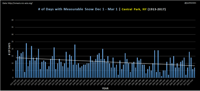
While the number of days in which measurable snow is recorded each winter has decreased, the number of days with measurable rainfall has increased. With this pattern you might expect that snowfall in NYC is on the decline, but that is not the case. The chart below shows there has actually been a slight increase in snowfall for the Dec-Feb period since 1913.

Increasing amounts of seasonal snowfall during a period of time when the number of measurable snowfall events is decreasing seems, on its face, counter-intuitive. However, this can be explained if we examine the change in the numbers of large snowstorms impacting NYC over time. In recent years high end coastal storms (HECSs) have seemed to target the NYC area with a regularity not observed in previous climate periods. Some evidence for this phenomenon is shown in the chart below which documents the number of 10"+ snowstorms by decade in Central Park, NY. (It should be noted that this chart includes all snowfall events- even those outside of the aforementioned Dec-Feb period).

No two-decade period in recorded history rivals the number of double-digit snow events NYC has seen since the turn of the 21st century- a period of only 17 years. This is a good indication that shifts in our regional climate have landed us, at east temporarily, in a period of time that is conducive to producing large snowstorms in the NYC area (at east more conducive than in the past). The question is- why, and how long will it last?
Follow-up: Changes in major (10"+) vs significant (6"+) snowstorms and implications...
The threshold for “big snowstorm” is another arbitrary choice that can easily alter the results of a study. My decision to use 10” for defining major storms for NYC was, in part, that I already had the data available from another project. I do think that is a representative number for major events- I could also see using 12” for that purpose.
After this post originally went up, it was suggested that I look at changes in the frequency of 6” storms. Storms in the 6-10” range are certainly significant events, and make up a large portion of the NYC snowfall record. What I found was interesting; unlike 10”+ storms, the number of 6”+ storms has been on the decline. See chart below.

This would seem to further bolster the idea that major snowstorms (those producing 10”+) are making up a more significant part of the seasonal snowfall in NYC since seasonal snowfall has been on the rise over the last 2 decades. One way to quantify this trend is too calculate the percentage of each season’s total snowfall that is produced by the largest storm for that year. Averaging these percentages over a decade should smooth outliers and provide numbers useful for long term comparisons. As shown in the chart below the largest storm of the season is indeed making up a larger percentage of the seasonal total. Also evident is the recent increase in the size of the average largest storm for each decade. For the first time in over 100 years of record-keeping the average largest storm of the season is now greater than 12” in NYC.

With more of the snowfall for each season being produced by the largest storm the door would apparently open for greater season-to-season variability. In the same way a homerun hitter who is always swinging for the fences will strike out a bunch, so too will NYC winters fail to produce if that “big one” doesn’t show up.
-Josh